Monday, March 26, 2007

Mana Wahine Walk

While a few of us were concentrating solely on our WaterTribe Everglades Challenge, three young Kiwi women were just completing a three-month off-the-beaten-track traverse of the Southern Alps of New Zealand, from the bottom to the top.

I wanted to take the time to salute them.


Mana Wahine Walk – “strong women walk” – the expedition covered around 1600kms, passing through some of the most wild, untouched landscape NZ has to offer.

They tramped (Kiwi for ‘hiked’) through totally wild areas in Southland and Fiordland, climbed over snow-capped peaks and scaled some fantastic alpine rock routes. Hey, they even kayaked three of New Zealand's most memorable lakes (Hauroko, Manapouri and Te Anau), walked some of the country’s most famous tracks (such as The Dusky Track, the Keppler and the Routeburn), crossed 21 amazing alpine passes (such as Broderick and Rabbit), and the Tasman Glacier.

Their mission was to raise awareness for Youthline, a NZ charity specialising in youth development.

Their hopes for the trip?

To inject young people with a passion for the outdoors
To encourage an adventure ethic that will help build self-esteem
To encourage respect, for self, for others, and for the environment

Totally Bubba Girls.

Sunday, March 25, 2007

Not paddling, hon. Honest

So what do post-Everglade Challenge WaterTribers do when they’re not paddling? Of course, they start dreaming about next year’s EC, but they’re also very careful not to talk out loud about it too much, or to actually sign up so soon on the WaterTribe site for 2008 – that’s a bit too public, and FlysWithKiwiBird knows exactly where that page is now – and they start mulling over when they may be able to fit in a quick after-work or weekend paddle, just to keep the cobwebs from collecting on the boat as it sits so forlornly in the back yard. They ruminate (again, not out loud) over what gear worked well in this year’s EC and what would be a good idea to upgrade to – so they quietly order a few wee things here and there, just to remind UPS where the front door is. They definitely check the WaterTribe discussion forum fairly regularly – there’s always a good bit of advice on there, a comment to bring a smile to one’s lips and a trigger of a great EC memory or two.

But this KiwiBird has been kept pretty busy and has been warned not to even mention the word kayaking for a wee bit.

Summer’s on the way, so the pool cover had to come off – that took some scrubbing both sides and to be dried and folded away ready for the end of the season (heaven forbid). The lawns mown for the first time this spring. And, of course, the big project is finishing as quickly as possible the nursery for Andrew’s imminent arrival (May 8). Much to FlysWithKiwiBird’s chagrin - who's currently back in San Diego for the West Coast baby shower - this just had to be put on hold until after the EC. But now that’s over, I’m into slave and placation mode. “Yes, dear” is my mantra for the next few weeks as I putty, spackle, sand and paint.

And dream…

Saturday, March 24, 2007

NZ in the USA

It’s been a fairly important time in NZ politics this week, with Prime Minister Helen Clark meeting with Condoleezza Rice on Tuesday, and then George Bush on Wednesday (Rueters photos above). A free trade agreement (FTA) has always been at the forefront of any NZ mission to Capitol Hill, which was stymied some 20 years ago when NZ banned nuclear warships from NZ waters, effectively cancelling the 35-year ANZUS military alliance (joint Australia-New Zealand-US). The country’s new legislation established NZ as the first ever, single-nation, nuclear weapons-free zone, and the only country that has put its nuclear-free policy into law.

Wednesday’s big step seems to be that Bush conceded that New Zealand's anti-nuclear policy is strongly supported by Kiwis - some acknowledgment that America no longer seeks to change it.

NZ’s relations with the US goes a long way back, not as far as with the UK, of course (the ‘mother country’), but NZ is one of only two countries that has stood by the US in pretty much every war since WWII. We sent (and lost) troops to Korea, Vietnam, the Indonesia-Malaysian Confrontation, the Sinai, Bosnia, Somalia, Haiti, Kuwait, Kosovo, East Timor etc; NZ troops were sent to the first Gulf War and are currently serving in Afghanistan. And even though we officially condemned the current Iraq War, we sent defence force personnel there to help with post-war reconstruction and the provision of humanitarian aid.

In 1976, NZ’s new National Government announced that it would welcome nuclear-powered and nuclear-armed warships. There were massive street marches in response, and the USS Truxton was brought to a resounding halt by a spectacular protest fleet of 80 vessels, ranging from bathtubs to gin palaces, sailed, paddled or rowed out into Wellington Harbour (our capital), making a physical blockade to stop the US warship.

Election year again in 1984. As the election approached, as a result of intense public pressure, the Labour party committed itself to work actively for a nuclear-free Pacific, and to ban nuclear-powered or nuclear weapon carrying ships. The US decided to test the resolve of the new Labour Government by requesting permission for the USS Buchanan to visit, an obvious rust bucket but still operating under the neither-confirm-nor-deny policy whether it was nuclear-powered or carrying nuclear weapons. David Lange, the new Prime Minister, showed he meant business by saying, “No”.

So after Helen’s visit this week, the FTA is still hanging, but perhaps the US now recognizes that small countries can still support a super-power in general terms and yet appreciate that they can be a positive force for democracy by sticking to their (non-nuclear) guns within their own small borders.

PS. I had a real treat Thursday night - Canadian Ckayaker stayed with us on his journey from Florida back home to Quebec - and SandyBottom joined us for dinner. Just wonderful meeting this absolute gentleman and hearing all about his family and stories from his youth to present day. What a great tool these blogs can be. And one never knows, there could be a paddle way up north on the cards one day...

Friday, March 23, 2007

Everglades Challenge report: Day 7

CP3 to Key Largo
Four or five WaterTribe crews slowly mulled around the marina fingers where our boats had been tied up overnight. Silently and stealthily we one by one made our headtorch-lit ways out into Florida Bay for the final 35 miles leg of the 2007 Everglades Challenge.

SandyBottom and I paddled across to Joe Kemp Key, intent on a short cut. We should have known better. A few circles later, in the very dark, we finally got ourselves back onto Tin Can Channel. In the shallows I disturbed something sleeping. In a huge splash it soaked the heck out of me, and scared the heck out of me. SandyBottom said she couldn’t see me but could definitely hear my reaction from across the water.

Dawn slowly broke and I moved ahead of SandyBottom. We were on our own for this last leg. I caught up with Tyro and PaddleCarver and we chatted away as we paddled together. On the stretch across to Dump Key, I slowly pulled away from these marvelous gentlemen.

Navigation-wise, it turned out to be a fun day. I left the GPS to its own devices and concentrated mainly on my compass and the course I’d previously marked out on my chart.

As the morning wore on, the wind died away, leaving a flat calm sea. It was fascinating seeing the vast spread of Florida Bay all around, and then marveling at the specific narrow channels to make one’s way across. Reaching Twisty Mile, it was just that – a snaky mile of stakes that offered just a couple more feet of water to pass from one stretch to another.

Passing Brush Key I laid a course of 120degrees for the long stretch to Jimmie Channel. Finally through there, and very shallow, I tried to read the markers ahead to bring me up the west side of Manatee Key. They were lost among the green of the key’s mangroves. In a wee bit of impatience and uncertainty, I used my Greenland paddle to push myself across the shallows joining Manatee and Russell Keys. I had been warned not to step out of my boat under any circumstances, that I’d be gobbled up by the mud and never seen again!

Looking back, I could see the definite markers for Manatee Pass – I’d know it was there, as the chart so rightly stated, for next year.

Immediately the water changed colour – from the murky sea of Flamingo to Manatee Pass, to a gorgeous chalky aquamarine. And immediately the wind kicked up. It was a pretty stiff head wind and two-foot chop for the rest of the entire leg. I felt that I was making interminable progress as Stake Key, and then Bottle Key, and then Butternut Key slowly crept past. But kind of happy at the same time – I didn’t want to rush finishing such a great adventure.

Aside of Butternut Key I realized that I’d slogged up a bit high. It was great to be able to raise the Pacific Action Sail for the last time and I had an excellent off-wind ride back into the main channel, lined up for the last three mile or so slog up to Baker Cut.

Roo and Tinker’s EC22 sailed swiftly up to greet me. On board was Roo, SOS, DancesWithSandyBottom and Wizard, all out to welcome the last few WaterTribers coming home. I warned them that they were a wee bit behind me.

They headed off back to Key Largo, tacking all the way up to Baker Cut. It was fun to very nearly keep up with them as I kept up my direct slog into the wind.

Around Baker Cut corner, past Pelican Key, and I headed across into Sunset Cove. It was hard to believe, and somewhat sad, that these were my last few metres of paddling. There were WaterTribe waves from the jetty, and I gave a last quick paddle to push my boat up on to the beach. It was 15:08, and I’d been on the water for just over ten hours. There, waiting for me on bended knees with flowers and a very welcome cold beer, was a friendly face – KneadingWater.

Thursday, March 22, 2007

Everglades Challenge report: Day 6

Last leg of the Wilderness Waterway
0400. “Are you awake, Dawn?” “Yep.” “Let’s go. I can’t sleep either.” So off we went. Thankfully the tide was up and we could repack our boats leaning over the side of the chickee. The snoring continued behind us as we softly paddled off into the dark. The stars were still magnificent.

And for the very first time in our Wilderness Waterway adventure, there was a current helping push us along. It had to be a good sign. Surely KneadingWater would be waiting for us at Oyster Bay Chickee.

Down the Harney River we paddled, following the track of the rising sun. Not a breath of wind, we silently slid along. At marker 9, we turned into Shark River. At Shark River Chickee, around 0730, SavannahDan and Paddlemaker were still fast asleep. SandyBottom made a short detour to check if KneadingWater was also there. He wasn’t.

Into Whitewater Bay we paddled, sails up. At marker 2 we made a detour for Oyster Bay Chickee. Surely KneadingWater would be waiting there for us. 0900, and he wasn’t. SandyBottom was almost beside herself. I managed to persuade her to wait until we got to Flamingo before we called the Coast Guard.

We had a good following breeze for most of Whitewater Bay, but in the last few hours, the wind died out completely and the temperatures hit the upper C20s or F80s. We were both pretty quiet.

Entering Coot Bay, a tourist boat passed us. Over his loud speaker, the tour guide asked us if we were doing the Wilderness Waterway and how long it had taken us. We were, SandyBottom acknowledged, and it had taken us two-and-a-half days. “That has to be a record,” the guide explained to his followers. “Normally, folks take ten days doing about ten miles a day.” SandyBottom and I looked at each other.

The last mile or so down Buttonwood Canal, I turned to SandyBottom. “I’ve been thinking what we should say to who ever the race manager is at Flamingo. Let’s ask if KneadingWater has checked in. If he has, fine. If he hasn’t, then we can say we may have a small problem.” SandyBottom had been thinking along the same lines. She was convinced he’d met his maker; I was pretty sure he was having a beer in Flamingo.

We reached the haul out ramp in Flamingo at 15:15, and SandDollar rushed to greet us. “KneadingWater’s checked in!” were her first words. News seemed to have traveled fast. We let the expletives fly and relief overcome us. And where was he so we could pummel him into unconsciousness? “He left early this morning for Key Largo.”

We found the trolley - one tyre now deflated - hauled our boats across to the seaward side of Flamingo’s marina and tied them up to a marina finger – they almost looked like real boats.

It was a relaxed afternoon. We popped a hamburger in the microwave at the local store, and it was as good as the young salesman claimed. I had my last mouthful in my fingers as I scratched my head, and a seagull instantly stole it (and nearly my finger). We even had an ice-cream for desert.

We emptied our boats and repacked everything in preparation for tomorrow’s final leg. We beat off the pelicans as they came to claim anything not tied down. We chatted with the four or five other WaterTribe crews working alongside us. And we slowly waited for dusk so we could find somewhere to stealth camp for the night.

With a perfect Florida Bay sea view, albeit dark, SandyBottom and I pitched hammock and tent respectively, tucked away out of harm’s way, and slept soundly until I woke her at 0400.

Wednesday, March 21, 2007

Everglades Challenge report: Day 5

Half-way through the Wilderness Waterway
Unbeknownst to KneadingWater, we were dragging his slumbering body out of his pit at pre-sparrow fart – 0430 – he succumbed with remarkably good grace. Well on our way, around mid-morning, he decided to take a stretch at Rogers River Bay Chickee – where we’d actually meant to stay the night. Just leaving there was Tim – a chap in a single kayak in his late sixties, puttering around the ‘glades for a few days. He sounded British.

We agreed to all catch up again at the end of Cabbage Island Channel, a shortcut KneadingWater had recommended, meeting up with Broad River. If we missed each other, we’d call on channel 69 at 10:30.

We never saw him again, until the finish at Key Largo.

Sandybottom and I cruised down Cabbage Island Channel, which is only 10-15ft wide, with a few fallen trees here and there, but completely manageable. Here we saw ‘gators to match all ‘gators. A few small ones sunning themselves on the side of the bank, and then big-momma – all 18 or so feet of him or her.

At the T-junction of the Channel and Broad River we delighted at the speed the current was heading out – we’d be at the coast before we knew it. We waited for KneadingWater, and we waited some more. We called him on the VHF every five minutes – nothing. We finally decided that he’d fallen off the chickee, knocked himself out, his boat had blown away and he’d drowned. Personally I thought he’d gone the other way around to show us how fast he really was – men can pull tricks like that. So back we paddled the nearly three miles to Rogers River Bay Chickee. Got within a few feet and yelled ourselves hoarse – no boat, no body, no KneadingWater.
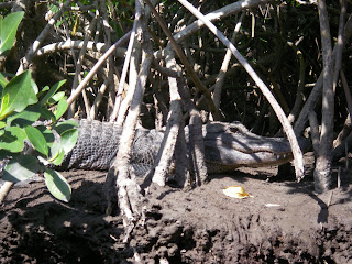
Anger was turning to fear by this time. SandyBottom was convinced that, if alive, he’d wait for us back at the intersection of the Channel and Broad River. So back we paddled another three miles down Cabbage Island Channel – this time the 18ft ‘gator slowly slid off the bank and idly cruised towards us...

Back at Broad River, no KneadingWater. And now the tide had turned and the current was 3-4mph against us. It took us four hours to make the coast. (We learned later that KneadingWater had taken another channel and had caught the tide out Broad River, making that leg in well under an hour.)

Just before we hit the coast, we met two chaps in a speedboat hunkering down for the evening at Broad River Chickee. No, they hadn’t seen a chap in an orange kayak, but shared our now growing concern. They also warned us that it was pretty rough outside and they wouldn’t be heading out there if they were us. We left them, and before hitting the coast, pulled over and clothed up. We should have waited until we’d actually got there. It was flat calm and still quite warm in the waning afternoon sun. We took everything off again.

Down the coast we paddled, marveling at the destruction the hurricanes had caused on the shorelined trees. We slipped into Broad Creek and continued east down the Wilderness Waterway (WW). (Later we learned that KneadingWater had come in at Harney River, thus another opportunity to catch up had been lost, and he’d gained even more hours on us by missing the upcoming tangle of Broad Creek.)

Night fell. Between markers 17 and 16, the WW truly became the WW. In pitch black, for almost a mile, we crept through fallen trees and mangroves, branches breaking off all over us. At one point, with two logs across our path, I saw the fortitude of SandyBottom that has got her three previous ECs and the Ultimate Florida Challenge – nothing was going to stop her – and it took some maneuvering to get her bigger Kruger under and around those fallen logs.

Every now and then we’d double check that we hadn’t taken some other non-existent route, but both chart and GPS can’t be wrong.

Our plan, and permit, was to camp at Oyster Bay Chickee for the night, but we’d lost hours waiting and searching for KneadingWater. We decided to stop for the night at Harney River Chickee. Surely KneadingWater would be waiting there for us. Tim, the chap we’d met earlier in the day, was already in his hammock as we arrived. But no KneadingWater.

“Are you British?” I asked Tim as he so wonderfully helped us shore up and unload, the tide being quite a way down and the ladder a good clamber out of an ocean cockpit. “No”, he replied. “It’s just an affected accent.”

We strung hammocks, gobbled down some food, and listened to Tim tell us that KneadingWater’s disappearance was bound to be a Federal case and that we should be calling the Coast Guard. Although very helpful otherwise, these comments were not. I could see me losing my Green Card application. I could see Chief spitting tacks. I was trying to figure out which was the worst scenario. The worry over this kayaker I’d only met a few days previously, but had taken a liking for, was killing us and ruining our trip.

An hour later SavannahDan and Paddlemaker cruised their way past. No, they hadn’t seen KneadingWater.

Another hour later, Frogy130 and CatLady arrived in their sit-on-top tandem, and joined Tim on his side of the chickee. They, too, hadn’t seen KneadingWater.

The snoring levels increased ten-fold.

Two hours later I heard the unmistakeable crunch of fiberglass – jumped out of my hammock to find the tandem slowly being crushed with the rising tide trapping it under the chickee. It took all of my 125lbs standing and then jumping on it to free it.

The snoring continued.

We got some sleep…

Tuesday, March 20, 2007

Everglades Challenge report: Day 4

Entering the Wilderness Waterway
Novel beginning to this morning’s Everglades Challenge – we actually got to sleep in a few hours. The Ranger’s station didn’t open until 0800, so we were stuck until then. Dr. Kayak kindly drove me, SandyBottom, KneadingWater and the Lori half of NatureCalls the few miles up the road, and we were second in line when the station doors opened.

The night before – must have been the hot pizza - both Kneading Water and I agreed to accompany SandyBottom on her quest for the coveted alligator tooth. One of her reasons for using the Balogh sailing rig this year, was to pick up some extra time so she could fit in the one or two additional days and 30 additional miles to complete the Wilderness Waterway (WW). Hey, I could see myself with a coveted alligator tooth, and I was a day and a half ahead of my personal schedule – what was the point of beating all the boys and sitting on a beach for three days when I could be paddling! KneadingWater had already completed the WW a year or so earlier, so he was along for the ride.

Instead of leaving direct from the northern side of Chokoloskee, we carried the boats – fully laden with straps – across the road to the eastern side. This saved us an extra mile or so of paddling around the bottom of the island, and after watching ShallowMindedII spend nearly an hour dragging his boat out through the mud, we were so sure we’d made the right decision.

And feeling as though we were on spring break, off we went – about 10:00. Full of good plans to make the camp spots we had on our Everglades permit, we charged forth. Convinced I was finally going to see an alligator, I had my eyes peeled. And sure enough, paddling through the narrow channel of Alligator Channel, there s/he was in his/her full 5ft glory. Very cool.

I hadn’t quite expected what the WW was – huge ‘lakes’ connected by varying sizes of channels – and so it goes on. And before we knew it, lethargy had taken over. Well before any respectable WaterTriber would stop for the night (after a mere 25 or so miles of paddling) we weighed anchor at Lostmans Five, a ground site. We even had a hot meal before the sun went down.

Early to bed, male snoring did its bit, not counting the endless rustle of palm rats tearing circles around my tent and occasionally banging into it, as well as a raccoon who somehow managed to get hold of a glow stick, which left a pleasant aurora near the end of my tent for a good few hours. All-in-all, a restful night.

Monday, March 19, 2007

Photos: Everglades Challenge 2007

The weather didn't quite comply for the first few days in helping to take photos, but at least I managed a few. May just have to do it all again next year... If you click on 'Watch the Show', the pictures will come up full screen.

Everglades Challenge report: Day 3

Day 3: Wiggins Pass to CP2
Dawn was just breaking as I paddled with the tide out Wiggins Pass. SandyBottom and NatureCalls were minutes behind me. I headed fairly well out to see if the swells would decrease as the water got deeper, but I think the opposite happened. Conditions soon settled into a 15-18knot NNE, 8-10ft northerly swells, with a sometime cross swell from the wind. This turned out to be the most exciting day of the entire EC - pure exhilaration, tinged with a fair bit of “scary”!

SandyBottom came up behind me with aka flapping, but latched on to her and with the swell, there was little I could do to help clip the lashing back on. I let her go and she waited for NatureCalls, a tandem kayak with the same Balogh rig, to catch her up. She figured she’d have to do a beach landing to fix it, but she told me later that Jim and Lori had managed to raft up with her and fix the problem on the water.

I was on my own, a good three or so miles offshore, for pretty much the rest of the morning. What a ride. The surfing was something else, and many a time I found myself bracing out to windward, using my Greenland paddle as an ama and aka, fluttering across the sea as a brace. At one stage I heard a wee train roaring up behind me, and a wave broke across the top of me. There were times, with spray flying, that I couldn’t even see. Later I found that I’d reached 11.9mph on one particular surf – pretty much all that morning had been similar on the downwind waves.

By now I’d figured my TravelMate for urinating just wasn’t working for me – I couldn’t get high enough in my seat to get a flow going, so I was just peeing in my sponge. For this trip from Wiggins Pass to Marco, there was no way I was able to lift my spray skirt, so I just peed in my shorts, the rapid flow foot pump making quick work of any spray etc.

Shortly before Big Marco Pass, SandyBottom and Nature Calls caught up with me, and for a few hours we had a great trip together down the coast – nice to see a 1sqm Pacific Action Sail keeping up with two fully rigged Balogh sails.

My original intended route had been to head in at Big Marco Pass and cut through the inside channel to reach the beginnings of the Everglades’ 10,000 Islands. I’d even had a possible exit at Gordons Pass planned (hadn’t looked too good as I’d charged past, though I found later that others did go in this way). Instead, with the favorable following winds we now had, and the slightly calmer seas as the day wore on, the three of us decided to pass by Big Marco Pass and cut in via Caxambas Pass. We could see Maggie heading way down Cape Romano to make his entry into Chokoloskee.

The tide was with us as we rounded the point into Caxambas Pass, and we left the last big high-rise buildings behind us. We paddled inside Helen Key, weaving our way around the mangrove islands, finally coming out below Tripod Key. From there, it was near a direct shot to Indian Key and the entrance up into Chokoloskee Bay. We had calm seas and fair winds most of the way, with sails set and paddles dipping.

Around 16:00 we realized that we were going to miss the Everglades City Rangers station to pick up our permits for the Everglades, the office closing at 16:30 – we had nine miles to go and all against the tide. I couldn’t see the point in resting on an outlying key to wait for the turn of the tide, so up we paddled – flat calm and no wind whatsoever.

Before entering Indian Key Pass, I’d hitched a ride on SandyBottom’s inflated aka – you should have seen her face when I inadvertently pulled out the valve and the entire aka deflated in seconds. Muttering that she’d now have to find her footpump, I assured that I was normally full of hot air, and reinflated it by mouth within seconds. “Don’t lose the valve!” she warned.

We probably only paddled 1.5mph or so as we slowly plodded up Indian Key Pass, in fact it took us four hours to make those last nine miles. We passed Maggie slowly tacking and paddling up. That slow, I could well appreciate the scenery around me. By the time I finally hit Chokoloskee Bay, the sun was setting behind me in a deep red glow. Nature Calls, with two paddlers, had reached the starboard turn across the Bay ahead of me, and were gone in a puff as a slight northerly came up. I too used my sail to finally reach CP2 in the dark, arriving at 19:15, charting a total of 174 miles since the start of the race. It had certainly been feast or famine today, with over 56 miles, a maximum speed of 11.9mph (a personal record), a moving average of 5.5mph and an overall average of 4.3mph.

SandDollar was there to greet us and show us the motel room the Tribe had for its use – loved the service – even fresh pizza! A hot shower later, we welcomed SandyBottom arriving on the beach and, much later, while were asleep, KneadingWater. Instead of sleeping in the hotel room, we opted for pitching our tents right on the landing beach.

I fell asleep to the lulling voices of Chief and Dr. Kayak...

Saturday, March 17, 2007

Everglades Challenge report: Day 2

Day 2: CP1 to Wiggins Pass
Dawn breaking, I quietly paddled out of CP1, resolved that in future ECs, I’d quickly check in, and then head out again to camp on one of the spoil islands just out from Gasparilla Bridge and not another 15 minute paddle from that first checkpoint. I was to learn by the end of my first EC that running on the constant adrenalin over the six or seven days and with four hours sleep and an hour or two of dozing is just fine to keep going by, but that the snoring of my fellow male competitors is debilitating.

I’d packed up camp at CP1 and was on the water by around 0600. SandyBottom had left a half-hour or so before me. It was a calm paddle across Gasparilla Sound. Reaching Charlotte Harbor, I could see SandyBottom ahead, following the Intracoastal, bearing much further to starboard. I took a more direct course across Charlotte Harbor, for the eastern end of Punta Blanca Island. It soon turned a bit lumpy, but made good time.

At Punta Blanca Island I passed Pelican, who told me that he’d had to head back to the start the day before to pick up the foot paddle unit he was supposed to be testing. He’d camped the night at Cayo Costa. A pod of dolphins played beside us.

Past Punta Blanca Island and Cabbage Key, the expanse of Pine Island Sound opened up before me. It was merely a matter of following the channel markers all the way, and dodging the occasional tug and the wakes of the motor boats roaring by. It was still blowing a NNE, about 10-12knots, which encouraged a lumpy chop, but a good reaching breeze for the Pacific Action Sail. I was soon to pass NiteNavigator and NiteSong, paddling merrily away. Couldn’t hear Jan singing, though.

By the time I reached the bottom of York Island, I was paddling into a pretty stiff headwind, only making a few mph. I could see Pelican further inside Sanibel Island, and SandyBottom near him. She soon took down her Balogh rig, and it looked as though she was anchored. Later she told that she’d been paddling, but hadn't been making any headway.

Right on the edge of the channel off Picnic Island, a yacht had run aground and a couple of launches were trying to drag her off. Not much I could do to help as I paddled just a couple of feet from them.

Under the leeward shelter of Sanibel Causeway Bridge I phoned home and made my report. FliesWithKiwiBird warned me that there’d been some interesting chaos the day before, and subsequently there was now an eight-hour reporting rule. I’d try and conform if I could!

Now heading off the coast, the contrast was amazing. The wind dropped out entirely, the clouds had blown off leaving a sweltering sun, the sea was pretty-well dead flat, and I could hear the booming music of the Spring-break crowds partying along the beach. Still paddling forward, but with sail flopping, I dithered around for a bit trying to figure out my game plan. I felt good – should I just throw caution to wind and make a direct heading for Marco Pass and paddle through the night, as per my original schedule (I was a day ahead of myself already), or find somewhere to stealth camp half-way down the coast?

I had a few ideas of where I could possibly camp, but this was the stretch I was least familiar with from my chart studies. The previous evening at CP1 I’d asked KneadingWater his advice on a possible overnight stop, and he’d recommended Wiggins Pass.

I took a compass bearing from my chart and figured that the last landmass and buildings I could see waaayyy down the coast had to be Wiggins Pass.

A 35ft yacht slowly sailed past. “That’s a small sail you’ve got there”, the chap said. “Small boat”, I replied.

After an hour or so of paddling, the NNE wind hit back again, kicking up a good two to three feet of chop. A couple of miles offshore, I made good time to Wiggins, not seeing another soul since Sanibel Causeway Bridge. Nearing Wiggins, I could see the white caps across the north side shoals and figured to quit my shortcut and follow the channel markers in. Dusk was just setting as I surfed in on some of the last remaining swell and chop.

Tucked inside the north side of the entrance, I pulled up alongside a steep sandy bank and clambered out. Dragging the boat into the trees to hide it, I pitched tent and swiped bugs as they landed to feast. I made a quick call home to say I was safe and here I was and promised to call again once I was settled (which I forgot to do).

A small speedboat slowly puttered by. I ducked behind my boat and quickly switched off my headlamp. Out from the dark came a call, “Are you with WaterTribe?” So much for Kiwi stealth. I came down to the beach, and met Kon-tiki, his wife Heather and their pal Jason. They’d been out looking for fellow WaterTribers and had been taking shots of Team RAF and Pelican, a good three to four miles off the coast.

They beached and advised me that I was just fine where I was – this was the County Park, rather than the more officious State Park across the south side of the inlet – they knew all the County rangers by name, and as long as we were gone by 0800 the next morning, we’d be fine. So they helped me drag my boat out of the trees, I reset my tent on the beach and Heather, a professional photographer with Foster Photos, took a few photos. And lo and behold, just over an hour after I’d landed, in came SandyBottom and Nature Calls. We were soon all camped up together and out like lights.

A few hours later, through my sleep, I could hear the rattling of a Sea Pearl coming in. Turned out to be Maggie, who anchored just up the inlet from us. Another kayaker came in later and left much earlier than us – not too sure who it was.


It had been a great day - 51.8 miles in 12 hours with a maximum speed of 8mph, a moving average of 4.3mph and an overall average of 3.9mph.

* All people and boat photos courtesy of Heather, Foster Photos, taken at Wiggins Pass.