


Using the FEK sail I had a nice run across the very open eight miles of Tampa Bay, the forecast northerlies pushing us along. Half way across it steadily grew darker as a wide band of showers ran over, but quickly clearing. The winds calmed a little in the lee of the first bridge, and as we entered the big open expanse of Sarasota Bay, I was wondering if the stronger northerlies had faded out. I didn't have to wait long. About half-way across the bay, they kicked in, and it was all downhill from there. Running down Sarasota I hit my second top speed of the EC, at 8.9 knots, and was consistently running from 5.5 to 6.5 knots, averaging 4.5 knots over the entire day—in fact 4.5 knots for the next three days. Occasionally, the bow of the kayak would submarine, but the surfing was superb. (I so wished I had a GoPro camera to film it all!) A number of times the rudder couldn't cope, and I'd use my Greenland paddle to help steer.
I had one four minute pit stop along the way, drank three litres of 50% diluted Gatorade, and ate about six bars—it was the only day I was really hungry.

I was a bit surprised to see a few Class 1 and 2 folks out of the water, setting up tents, and not heading on down the coast. After a royal greeting by Floatsome (CP1 manager), who very kindly brought me a cup of hot soup (yum!), and directed me to the water filling station, in about 30 minutes, I was up and off, gently lowering myself back into my boat—the new checkpoint doesn't have a ramp. It was just dark as I left, and Jarhead in his Sea Pearl paddle sailed out with me—with another Sea Pearl—I passed them as we set off south.
My plan for the night was to paddle the nine or so miles south, to sleep the night at Dog Island, my usual stop just outside the old CP1. I had a terrific calm paddle sail, making the island in about 90 minutes. A large party was camped where we normally pitch our tents, with a huge wind block awning up and behind that a roaring fire. I paddled around to the east, and found a beach and small path up to a raised area. Tent was up in no time. An hour or so later, SandyBottom arrived, just as it started to rain. and it rained all night. It was the best night's sleep I was to have this EC.
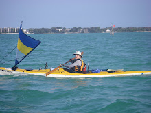
Top middle photo by SpeckTater.
Upper top and bottom top photos by Glen Hayes.
DAY TWO: Around 0400, the wind blew! It sounded like a mini hurricane, particularly with trees around us thrashing. I whispered out to Dawn, "Can you hear that?!" She could. We packed up in the dark, and by the time we were ready to leave, dawn had broken and the wind had calmed considerably.
Paddle sailing south, we took a route for Bull Bay, but in trying to make a bit of east for Charlotte Harbour, I had us meandering too far east, finally doubling up and over to the eastern side of Bull Bay. Though we did find some possible camping spots...


And with the tide (going out), about half an hour before dark, I made Wiggins, seeing it from the rear for the first time.
Tent up, can of sardines down, dark fell, and a few more boats started slowly arriving. I hit the sack, and SandyBottom arrived a few hours later.
DAY THREE: Up in the dark, Dawn and I headed off just as dawn broke. We decided to head out Wiggins Pass together, in the interests of safety, with the seas being against the tide. Heading out wasn't too bad, with some breaking waves around two metres. (We later learned that a couple of kayaks behind us had capsized.) I pulled away, and wouldn't see SandyBottom until the next day.
Jungle Jim was paddling his Epic 18Sport ahead of me, and a wee while later, CWolfe passed by in his Kruger, with full Balogh flying and a two-metre PAS. With a pretty consistent 4.5 knots paddle sailing, I later passed JungleJim and then CWolfe. With superb surfing skills, JungleJim was soon to retake the lead.

I later realized that the reason I'd missed seeing Gordon's and Big Marco was because I was off the coast a way, and had been looking out to sea more, watching the sometimes breaking swells.

Finding the tide coming into Chokoloskee, I just kept on paddling up to the Rangers Station, outside of Everglades City. Just before entering Chokoloskee Bay, a skiff with two Rangers powered past me, on their evening patrol. By the time I reached the Rangers Station, about 30 minutes before dark, they'd returned to the dock. I paddled up to them, took off my hat and signaled I wanted to chat. They spoke first: "Are you with WaterTribe?" "Is it my hair?" I responded. I explained that I was a night ahead of schedule, and not having anywhere to camp, would they mind if I left my boat at the ramp and pitched my tent behind the shed there. "It's against Park regs, you know. But okay." I thanked them profusely and paddled around the corner.
I called WhiteCaps/Toby, manager for CP2, and let him know where I was, and that I couldn't be bothered paddling all the way to CP2, to have to paddle back in the morning for the permits we'd need for the Wilderness Waterway, and then back again. He understood,even though it would mess up my CP arrival times (as soon as I hit CP2, I'm on holiday!), and was around with JungleJim in about half-an-hour to chat. Always good to see Toby.
I pitched my tent, cleaned up, and staggered drunkingly across the road to the fish restaurant, where I delighted in grilled scallops, shrimp and grouper, washed down with a Heineken.
Terrible night's sleep, and I don't think I'll camp there again! Around 0200, and for the next two hours, all the big dieseled fishing boats left Everglades City, less than a kilometre away. It was deafening!


No comments:
Post a Comment