Day 2: A few miles shy of CP1 to
But the real delight of being shy of CP1 (apart from dragging our boats down the mud, as per the photo above) was that for the first time I actually got to see in the daylight those last ten miles or so, in previous ECs spent in dark, scary obliviousness. And very scenic they are too. You can now see the car ferry crossing, rather than just hear those enormous motors bearing down on you.

Photo by Amy: replenishing water supplies at CP1
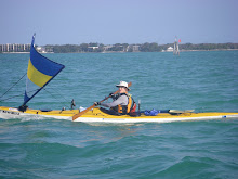
But after signing in, replenishing water supplies enough for the couple of days to get us to CP2, replastering sun screen and pressure points and the obligatory chatter, we were off. Into a stiff 10-15 knots headwinds and a very lumpy open harbour chop. We chopped up to Sandfly Key, taking what lee shelter we could, watching TroutHeart and Trader away to our left cutting into what shelter was possible, and there met up with SandDollar, DrKayak and StripBuilder.
To keep out of the hugely exasperating boat wake and chop of the Intra Coastal Waterway down western Pine Island Sound, we decided to head down the eastern side—a first for me—and what a blissful experience. Very few craft, well posted and not so “open.” But not before a very civilized lunch on a small white warm beach at the northern end of

Lunch stop,
As dusk crept on, the wind died away completely, a huge moon reflecting our every dip. Just KW, SB and me by this stage, trudging along around 2knots towards
But just under the bridge and around the corner to your left, a wee paddle past the bridge’s toll gates, is a length of sandy beach interspersed with the occasional shrub to hide oneself just enough behind. Here we found NatureCalls, tandem kayak drawn up the beach, tent pitched, sound asleep. And here we made our last stand for the evening. What traffic?

Image: Google Earth: camp spot outside


1 comment:
First the SPOTtie trail during the Challenge and now the full Report. What fun! Thanks.
Post a Comment