Dawn breaking, I quietly paddled out of CP1, resolved that in future ECs, I’d quickly check in, and then head out again to camp on one of the spoil islands just out from Gasparilla Bridge and not another 15 minute paddle from that first checkpoint. I was to learn by the end of my first EC that running on the constant adrenalin over the six or seven days and with four hours sleep and an hour or two of dozing is just fine to keep going by, but that the snoring of my fellow male competitors is debilitating.
I’d packed up camp at CP1 and was on the water by around 0600. SandyBottom had left a half-hour or so before me. It was a calm paddle across Gasparilla Sound. Reaching Charlotte Harbor, I could see SandyBottom ahead, following the Intracoastal, bearing much further to starboard. I took a more direct course across Charlotte Harbor, for the eastern end of Punta Blanca Island. It soon turned a bit lumpy, but made good time.
At Punta Blanca Island I passed P
 elican, who told me that he’d had to head back to the start the day before to pick up the foot paddle unit he was supposed to be testing. He’d camped the night at Cayo Costa. A pod of dolphins played beside us.
Past Punta Blanca Island and Cabbage Key, the expanse of Pine Island Sound opened up before me. It was merely a matter of following the channel markers all the way, and dodging the occasional tug and the wakes of the motor boats roaring by. It was still blowing a NNE, about 10-12knots, which encouraged a lumpy chop, but a good reaching breeze for the Pacific Action Sail. I was soon to pass NiteNavigator and NiteSong, paddling merrily away. Couldn’t hear Jan singing, though.
By the time I reached the bottom of York Island, I was paddling into a pretty stiff headwind, only making a few mph. I could see Pelican further inside Sanibel Island, and SandyBottom near him. She soon took down her Balogh rig, and it looked as though she was anchored. Later she told that she’d been paddling, but hadn't been making any headway.
Right on the edge of the channel off Picnic Island, a yacht had run aground and a couple of launches were trying to drag her off. Not much I could do to help as I paddled just a couple of feet from them.
Under the leeward shelter of Sanibel Causeway Bridge I phoned home and made my report. FliesWithKiwiBird warned me that there’d been some interesting chaos the day before, and subsequently there was now an eight-hour reporting rule. I’d try and conform if I could!
Now heading off the coast, the contrast was amazing. The wind dropped out entirely, the clouds had blown off leaving a sweltering sun, the sea was pretty-well dead flat, and I could hear the booming music of the Spring-break crowds partying along the beach. Still paddling forward, but with sail flopping, I dithered around for a bit trying to figure out my game plan. I felt good – should I just throw caution to wind and make a direct heading for Marco Pass and paddle through the night, as per my original schedule (I was a day ahead of myself already), or find somewhere to stealth camp half-way down the coast?
I had a few ideas of where I could possibly camp, but this was the stretch I was least familiar with from my chart studies. The previous evening at CP1 I’d asked KneadingWater his advice on a possible overnight stop, and he’d recommended Wiggins Pass.
I took a compass bearing from my chart and
 figured that the last landmass and buildings I could see waaayyy down the coast had to be Wiggins Pass.
A 35ft yacht slowly sailed past. “That’s a small sail you’ve got there”, the chap said. “Small boat”, I replied.
After an hour or so of paddling, the NNE wind hit back again, kicking up a good two to three feet of chop. A couple of miles offshore, I made good time to Wiggins, not seeing another soul since Sanibel Causeway Bridge. Nearing Wiggins, I could see the white caps across the north side shoals and figured to quit my shortcut and follow the channel markers in. Dusk was just setting as I surfed in on some of the last remaining swell and chop.
Tucked inside the north side of the entrance, I pulled up alongside a steep sandy
 bank and clambered out. Dragging the boat into the trees to hide it, I pitched tent and swiped bugs as they landed to feast. I made a quick call home to say I was safe and here I was and promised to call again once I was settled (which I forgot to do).
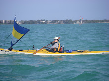
A small speedboat slowly puttered by. I ducked behind my boat and quickly switched off my headlamp. Out from the dark came a call, “Are you with WaterTribe?” So much for Kiwi stealth. I came down to the beach, and met Kon-tiki, his wife Heather and their pal Jason. They’d been out looking for fellow WaterTribers and had been taking shots of Team RAF and Pelican, a good three to four miles off the coast.
They bea
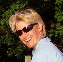
 ched and advised me that I was just fine where I was – this was the County Park, rather than the more officious State Park across the south side of the inlet – they knew all the County rangers by name, and as long as we were gone by 0800 the next morning, we’d be fine. So they helped me drag my boat out of the trees, I reset my tent on the beach and Heather, a professional photographer with Foster Photos, took a few photos. And lo and behold, just over an hour after I’d landed, in came SandyBottom and Nature Calls. We were soon all camped up together and out like lights.
A few hours later, through my sleep, I could hear the rattling of a Sea Pearl coming in. Turned out to be Maggie, who anchored just up the inlet from us. Another kayaker came in later and left much earlier than us – not too sure who it was.
It had been a great day - 51.8 miles in 12 hours with a maximum speed of 8mph, a moving average of 4.3mph and an overall average of 3.9mph.
* All people and boat photos courtesy of Heather, Foster Photos, taken at Wiggins Pass.


No comments:
Post a Comment