 Day 6: Flamingo, CP3 to
 At 0400 I reset the alarm to 0500. And at 0500 I reset it again to 0600. At 0530, guilt got the better of me.
With just a hint of dawn, NatureCalls wandered off to the store for breakfast, NiteNavigator and NiteSong (who had got in later in the night after once more completing the Wilderness Waterway) and WhiteCaps (who had got in much later after a windless sail around the
It’s a bit of a dog’s hind leg, the route out of Flamingo, and you’ve paddled near 3.5kms (two miles) to achieve what seems to be just a stone throw from Flamingo’s marina entrance. SandyBottom and I botched it badly last year, trying to take a short cut; and this year, in the dark, I found myself once again in Joe Kemp Channel instead of Tin Can Channel.
Back on course, I could just see NiteNavigator and NiteSong way in the breaking dawn’s distance.
 We hit even more severe head winds as we rounded Manatee Key. And this is where I let my concentration slip, thinking more of home and the WeeOne and a cold beer rather than my position and direction. The moral of the story being, if your compass chart work says 96degrees and you’re heading 120, your chart work is not wrong. And if your GPS’ purple line shows thataway and you’re heading thisaway, your GPS is not wrong – not matter how much you think they both may be. But sadly, NiteNavigator and NiteSong followed me. And I may have been just plain weary.
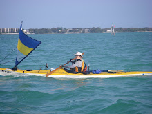
Instead of passing on the north side of Bottle Key, I paddled lower, directly into the wind above Stake Key to Low Key, leading us into a myriad of sandbanks. To escape, we found a small pass south of Bottle Key through Upper Cross Bank. But it was a long tiring paddle, into a brisk 15 knot headwind to reach the Intra Coastal Waterway, and head nor-west to regain all our lost ground and time. Just off Hammer Point we could finally ease off. If I hadn’t led NiteNavigator and NiteSong this way, I wouldn’t have felt so bad, as the 4.58 kms (2.85 miles) run from Hammer Point right up to Baker Cut was the best sail of the entire race; but they were solely paddling their Kruger. With Floatsome following me on my SPOT, he could see I paddle-sailed that 4.58 kms (2.85 miles) in 22 minutes – I felt as though I was windsurfing!
Up on the right course, under full Balogh rig, I could see NatureCalls tramping across the bay. I wasn’t to catch them, no matter how hard I paddled.
A mile or so from Baker Cut, out appeared Southern Skimmer, Roo and Tinker’s EC22, and Dawn Patrol, SOS and DancesWithSandyBottom’s Core Sound 20. And just approaching the finish line, SandDollar and Dr.Kayak appeared beside me. With everyone else lined along the dock, one always appreciates the rousing welcome!
What a ride!


1 comment:
Great account Kristen! Thanks for posting it for all us couch-kayakers lying about at home... Makes the snow storm I'm presently enjoying just a bit more fun!
Post a Comment